
Science
Overview
SEAFOs primary purpose is to ensure the long-term conservation and sustainable use of all living marine resources in the South East Atlantic Ocean, and to safeguard the environment and marine ecosystems in which the resources occur.
Scientists from Contracting Parties contribute to the assessment of marine resources in the SEAFO Convention Area and provide their scientific advice to the Commission through the Scientific Committee. Information related to the main SEAFO marine living resources (Species summaries) are updated annually, and include catch and effort information as well as additional information relevant to the stocks e.g. spatial and temporal distributions of fishing, length-frequency distributions, life history parameters and other population information, and incidental mortality (sea birds, mammals and turtles) and by-catch of fish and invertebrates.
Fishing Areas and Commercial Species
The SEAFO Convention Area (CA) is a large area with several seamount chains, isolated seamounts, guyots and banks, beyond national jurisdictions. All fishing in SEAFO occurs on or around seamounts. Nowadays vessels have mainly concentrated fishing operations on three distinct areas: Valdivia Bank seamounts complex, Meteor, and Discovery Seamounts. In 2013, the combined fished area was approximately 43,000 km2 (aggregated 100km diameter hexagonal cells where some fishing occurred), which represented 0.27% of the total CA of approximately 16M km2.
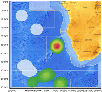
Kernel density plot of fishing effort (number sets, trawls) for 2005 to 2014. Prepared by G. Campanis (Secretariat).
The main commercial target species caught in recent years by fleets of members in the SEAFO CA are: deep sea red crab (mainly Chaceon erytheiae); alfonsino (Beryx splendens); Patagonian toothfish (Dissostichus eleginoides); and pelagic armourhead/southern boarfish (Pseudopentaceros richardsoni).
The orange roughy (Hoplostethus atlanticus) was the target species of an important fishery conducted between 1995 and 2005; also a recent fishery targeting the Tristan da Cunha rock lobster (Jasus tristani) took place until 2006 at Vema Seamount.
Fish by-catch is dominated by the blackbelly rosefish (Helicolenus mouchezi) in the Valdivia Bank trawl fishery; and macrourid species (Macrourus sp.) in the Patagonian toothfish fishery.
Topography and Oceanography
The prominent topographic features inside the Convention Area include the Walvis Ridge, which extends from around 18°S off the Namibian coast into a southwesterly direction towards the mid-Atlantic ridge; the mid-Atlantic Ridge, at around 15°W that runs through the entire SEAFO region from north to south; and the Agulhas Ridge, which extends from around 35°S south of Cape Town in a southwesterly direction. There are also numerous seamounts, guyots, banks and plateaus in the Convention Area; notably among these are Mount Vema, Valdivia Bank, Discovery seamounts and Meteor seamounts.
Circulation in the South Atlantic may be broadly cyclonic.The northern boundary of the SEAFO CA is bounded by the South Atlantic Equatorial Current that flows westward along the equatorial area. On the western boundary, the area is characterised by an open end of the South Atlantic gyre. The eastern boundary consists the Benguela and Angolan Currents along the African continent. The Benguela Current flows in a north to north-westerly direction (~15-35°S) and is a major east boundary upwelling system that is very productive in inshore areas and characterised by cool surface temperatures. The warm Angolan Current flows in a southerly direction along the Angolan coast and meets the Benguela Current roughly around 17-15°S commonly referred to as the Angola/Benguela front. The frontal area is characterised by offshore flow into the SEAFO area that transport primary production. The warm Agulhas Current flows south of the African continent in a westerly direction where it meets up with the Benguela Current.Warm eddies are formed in this area and transported northwesterly into the SEAFO area. The southern boundary of the Convention Area is dominated by the Southern Ocean Current and is also influenced by the Antarctic Convergence Zone.
Near 30°S, the Benguela Current begins to separate from the eastern boundary as most of the flow turns toward the northwest. This northwestward flow carries about 18Sv of surface water across 28°S, whereupon it turns mainly toward the west to flow over a relatively deep segment of the Walvis Ridge south of the Valdivia Bank. A surface current with northward speeds of 10cm s-1 was observed to flow along the western side of the Valdivia Bank, while another northward surface current of about 20cm s-1 was seen some 300km west of the bank (*).
Abyssal flows are affected by the topography. Deep flows often follow topographic contours and mixing can be related to the structure of the topography. The mid-ocean ridges confine deep waters to the abyssal basins. Fracture zones in the ridges allow for limited exchange through sometimes vigorous, turbulent low of waters from one deep basin to another. Bottom water coming from the Weddell Sea (Antarctica) is unable to fill the eastern part of the Atlantic basin directly due to the height of the Walvis Ridge (South Atlantic Ocean). Instead, the bottom water travels to the north along the western boundary of the South Atlantic, finds a deep passage in the MAR, and then flows south to fill the basin east of the ridge (**).
(*)Peterson, Ray G. and Stramma, L., 1991. Upper-level circulation in the South Atlantic Ocean. Prog. Oceanog. Vol. 26; 1-73.
(**)Talley, L., Pickard, G., Emery, W. and Swift, J., 2011. Descriptive physical oceanography: an introduction. Sixth edition, Published by Elsevier Ltd; 983 pp.
